The River State's Trusted Dredging Specialists
Alabama Lake, River & Coastal Dredging Specialists
We specialize in restoring water bodies across Alabama, providing essential river channel, lake, and pond dredging services from the Tennessee River Valley to the Gulf Coast. With more miles of navigable rivers than any other state, Alabama's waterways are our passion and expertise.
Trust our dedicated team to manage your water depth and quality needs in Alabama's unique river and lake ecosystems, ensuring your property value and aquatic habitat are protected for generations to come.
-
ADEM and USACE River & Lake Permitting Expertise
-
Tennessee River Basin & Reservoir Experience
-
HOA & Community River/Lake Solutions
-
Red Clay Sediment & Riverbank Erosion Control
About Alabama Dredging
At Alabama Dredging, we provide specialized dredging solutions tailored to Alabama's diverse river and lake systems, from the Tennessee River Valley in the north to the extensive river delta of Mobile Bay.
Our expertise includes addressing the unique challenges of Alabama's waterways, including sediment management in major river systems like the Coosa, Alabama, and Black Warrior Rivers, as well as tackling red clay erosion, boat-wake shoreline impact, and reservoir water level changes managed by the Tennessee Valley Authority.
We understand the critical connection between water quality and enjoyment of Alabama's prized rivers and lakes like Guntersville, the Tennessee River, Coosa River system, Lake Martin, and Lay Lake. Our team combines deep local knowledge of Alabama's river basins with technical expertise to deliver results that enhance both property values and recreational opportunities.
With years of experience working on Alabama's diverse watersheds and river systems, we've developed specialized approaches for both private residential projects and large-scale commercial waterfront improvements across "The River State."
Signs Your Alabama Waters Need Dredging
Alabama's lakes, rivers, and neighborhood ponds gradually fill with red clay, silt, and organic muck over time. Here are the most common signs property owners notice that usually mean dredging is needed.

Shallow Coves & Boat Bottoming-Out
Common on TVA-fed lakes (Guntersville, Wheeler, Lay Lake, Logan Martin) where sediment from feeder creeks and red clay runoff gradually fills in popular boating areas, making navigation hazardous.

Mucky or Soft Lake/Pond Bottom
When your feet sink into several inches of muck instead of firm sand or clay, it's a sign of organic sediment buildup. This affects both appearance and creates unpleasant odors in HOA ponds and neighborhood lakes.

Murky Water & Excessive Weed Growth
Sediment buildup fuels aggressive growth of hydrilla, milfoil, and algae, especially in Alabama's warm shallow waters, making swimming unpleasant and fishing difficult.
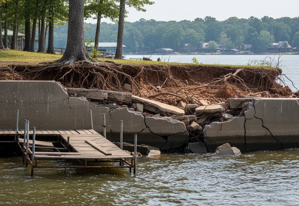
Erosion Around Shorelines & Seawalls
Wake boats and fluctuating water levels on Alabama's reservoirs cause significant shoreline erosion, undermining seawalls and docks, particularly on popular recreational lakes.

Poor Drainage or Flooded Stormwater Ponds
Common in Alabama subdivisions where retention ponds gradually fill with silt, losing water-holding capacity and causing flooding issues during our frequent heavy rain events.

Limited Dock, Ramp, or Channel Access
When boats regularly scrape bottom, pontoon lifts get stuck in mud, or fishing boats can't reach deeper water—clear signs that accumulated sediment is restricting waterway access.
Specialized Dredging Services for Alabama

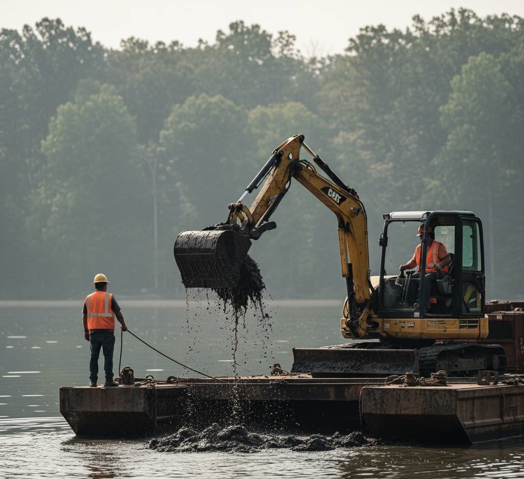
Mechanical Excavation Dredging
Ideal for coves on Lake Martin, Lay Lake, and neighborhood ponds across Alabama suburbs. We use sectional barges for precision sediment removal in smaller HOA lakes, handling heavy red clay and dense debris found throughout central and north Alabama.
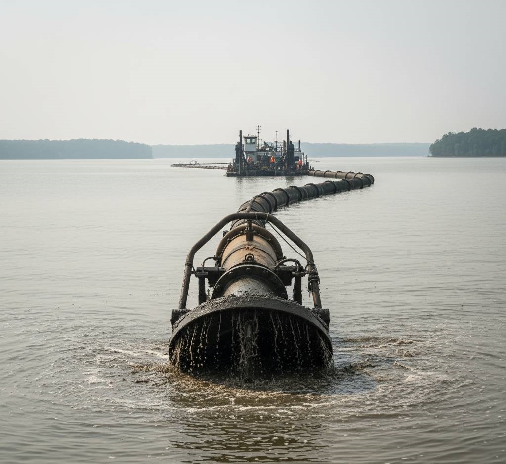
Hydraulic Pumping Systems
Best for large-scale operations on major water bodies such as Guntersville Lake, Wheeler Reservoir, and the Tennessee River system. Our equipment can pump fine silt and muck over long distances to remote dewatering sites, ideal for TVA reservoirs.
Integrated Sediment Management
A comprehensive approach ensuring compliance with ADEM regulations. This includes on-site dewatering using methods suitable for Alabama's diverse soils (from Tennessee Valley clay to Gulf Coast sand) with approved disposal or beneficial reuse planning.
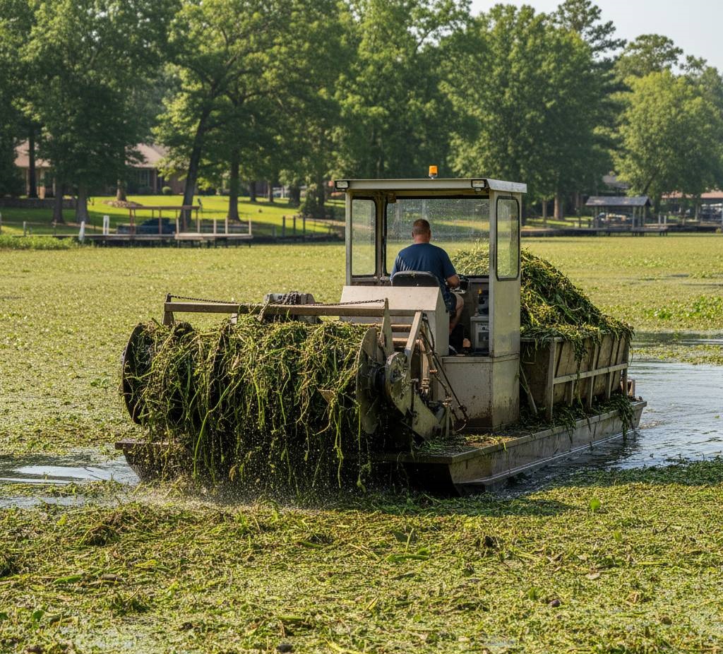
Aquatic Growth Control
Targeted removal of aggressive Alabama aquatic weeds—like hydrilla, water hyacinth, and milfoil—to combat the effects of shallow water and nutrient-rich sediment that cause severe weed infestations in our warm southern climate.
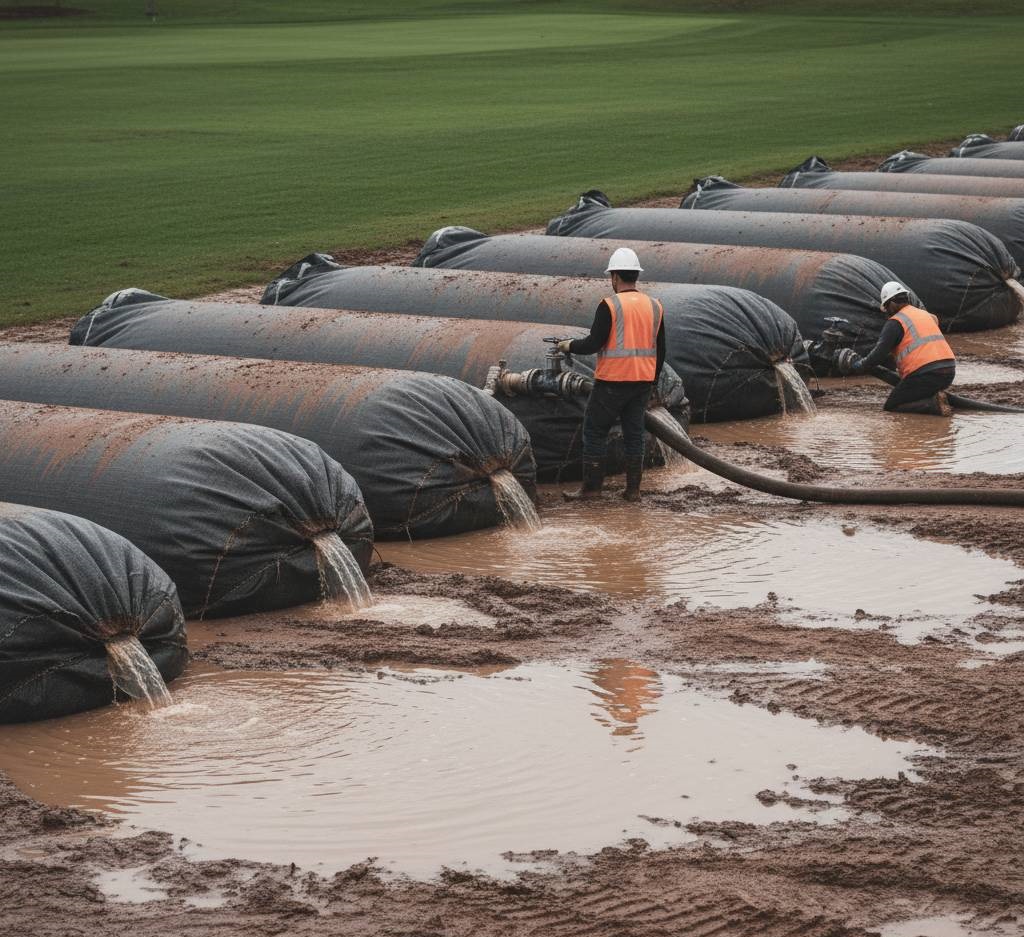
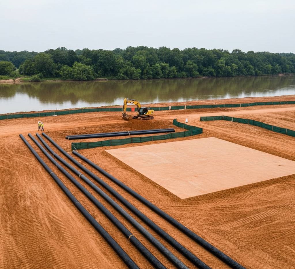
Advanced Dewatering Techniques
Installation and management of Geotextile tubes for efficient dewatering on HOAs, golf courses, and properties across Alabama. We also design and manage upland pad drying operations where available land permits, with special consideration for red clay disposal.
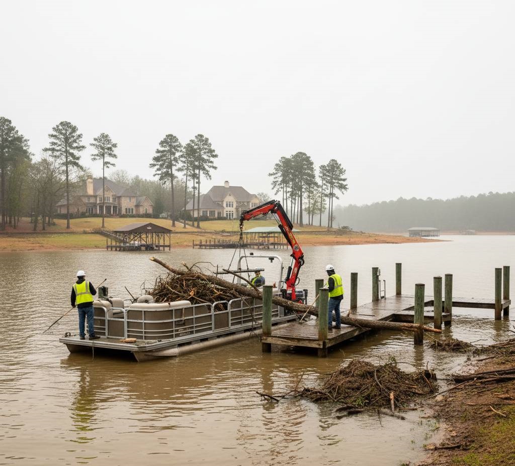
Waterway Maintenance Programs
Post-event cleanup and maintenance after major storms or TVA drawdowns. We offer season-based lake management programs to prevent sediment re-accumulation, particularly important during Alabama's hurricane season and seasonal water level adjustments.
Ready to Restore Your Alabama Lake, Pond, or Waterway?
The time to start planning is now. We consult with you to navigate ADEM permitting timelines, ensuring your project is ready before the busy pre-summer season. We can also work with TVA drawdown schedules for reservoir projects, or plan around hurricane season for coastal properties in the Gulf Shores and Mobile Bay region.
Get a Detailed Quote Give Us a CallFrequently Asked Questions About Dredging in Alabama
Dredging costs in Alabama vary based on several factors specific to your project. Key considerations include the volume of material to be removed, site accessibility, the type of sediment (red clay is often more challenging than sandy soil), water depth, and distance to disposal areas. TVA reservoir projects might have additional coordination costs. For a project-specific estimate that accounts for your unique location and requirements, we recommend scheduling a consultation with our team.
Alabama property owners typically consider dredging when they notice shallow water areas developing where deeper water once existed, boats scraping bottom in previously navigable areas, increased weed growth or algae blooms, sedimentation around docks and boat lifts, or unusual odors from decaying organic matter. After heavy rains, Alabama's red clay soil can rapidly accumulate in coves and inlets, making these issues more pronounced in certain regions of the state.
Yes, most dredging projects in Alabama require permits. The Alabama Department of Environmental Management (ADEM) oversees water quality certifications, while the U.S. Army Corps of Engineers (USACE) manages permits for navigable waters. Projects on TVA reservoirs like Guntersville, Wheeler, or Wilson also require TVA approval. The specific permits needed depend on your project's location, scale, and potential environmental impact. Our team can help navigate this process and ensure all necessary approvals are obtained before work begins.
Alabama's characteristic red clay sediment presents unique challenges during dredging. This dense material often requires specialized equipment for effective removal and can be more difficult to dewater than sandier sediments. We employ techniques specifically adapted for Alabama's soil conditions, including mechanical excavation for compacted clay and appropriate dewatering systems. In some cases, properly processed red clay can be repurposed for beneficial uses like fill material or erosion control, following all applicable ADEM regulations.
The Tennessee Valley Authority manages water levels on major reservoirs in northern Alabama, including Guntersville, Wheeler, Wilson, and Pickwick Lakes. These controlled fluctuations can significantly impact dredging operations. In many cases, we coordinate projects with the annual winter drawdown period, which provides better access to normally submerged areas. Planning around these scheduled level changes is essential for project efficiency and effectiveness, particularly for lakefront property owners in the Tennessee Valley region.
Yes, we provide specialized dredging services for Alabama's coastal areas, including Mobile Bay, Gulf Shores, Dauphin Island, and along the Intracoastal Waterway. Coastal projects often involve different challenges than inland lakes, including tidal fluctuations, saltwater considerations, and stricter environmental regulations. Our coastal dredging approach accounts for these factors, helping marina owners, canal-front properties, and coastal communities maintain water access while navigating the complex regulatory framework specific to Alabama's valuable coastal zone.
When properly planned, dredging can actually improve fishing habitats in Alabama's lakes and rivers. By removing excessive sediment and creating depth variation, dredging can enhance fish spawning areas and restore natural underwater structure. This is particularly valuable in popular fishing destinations like Lake Guntersville, known for its championship bass fishing. We work carefully to minimize short-term disruption while promoting long-term habitat improvements, often consulting with fisheries experts to ensure our approach supports Alabama's renowned freshwater fishing resources.
In many cases, dredged material from Alabama waterways can be beneficially reused, depending on its composition and contaminant levels. Clean sandy sediment might be suitable for beach nourishment along coastal areas, while properly processed clay material can sometimes be used for construction fill, agricultural amendments, or habitat restoration. All reuse must comply with ADEM regulations and environmental standards. We assess the characteristics of your project's sediment and identify appropriate disposal or reuse options that align with Alabama's environmental requirements.
Alabama Dredging Service Regions
We provide comprehensive dredging solutions across Alabama's diverse waterways, from the Tennessee Valley to the Gulf Coast, each with unique water management challenges and opportunities.
1. Central Alabama (Greater Birmingham + West AL + River Region)
The heart of Alabama, where the Magic City metro blends with suburban lake living, West Alabama's rich traditions, and the historic River Region. This corridor revolves around the Cahaba, Coosa, and Black Warrior Rivers, with popular waters like Lay Lake, Lake Jordan, and Lake Tuscaloosa shaping daily lake life. Here, Roll Tide and War Eagle fans live side by side along river-fed neighborhoods and community lakes.
Key AL Locations:
2. North Alabama (Tennessee Valley)
Defined by the Tennessee River and its TVA-managed reservoirs, North Alabama balances flowing river systems with backwater coves, tributaries, and sloughs. Work here focuses on keeping deep-water access, managing silt in current-affected areas, and addressing red clay and fine sediment that move with seasonal drawdowns and heavy rains.
Key AL Locations:
3. East Alabama – Auburn-Opelika & the Chattahoochee–Tallapoosa River Region
Where river systems and lake life meet. Anchored by the Auburn-Opelika corridor, East Alabama is shaped by the Chattahoochee and Tallapoosa Rivers with major regional waters like Lake Martin and Lake Harding, plus river-fed lakes along the Coosa chain (including Logan Martin and Neely Henry). Our work balances river current, watershed inflows, and red clay sediment that settles into coves, community lakes, and stormwater systems.
Key AL Locations:
4. The Wiregrass (Southeast AL)
A rural, agricultural landscape where ponds and warm-water rivers drive daily water management. The Wiregrass features the Choctawhatchee and Pea River watersheds, extensive farm and irrigation ponds, and subdivision retention systems. Projects focus on weed and algae control, sediment removal after heavy rains, and practical restoration for working properties and neighborhoods.
Key AL Locations:
5. Gulf Coast / Lower Alabama (LA)
Where The River State meets the coast. Mobile Bay, the Mobile–Tensaw Delta, and the Intracoastal Waterway define this coastal system, with tidal influence, brackish conditions, and storm-driven sediment movement. Canal maintenance, marina access, and post-storm recovery are core needs alongside year-round waterfront living and tourism.
Key AL Locations:
If you don't see your area listed, reach out — we frequently take on projects across rural lakes, private ponds, and unique waterfront properties throughout Alabama.